Caribbean Sea
January 15, 2020
local time 04.30
Location: 12 ° 05 ′ North 073 ° 35 ′ West
Distance traveled by S Lucia: nm 767 – Missing in Santa Marta nm 54
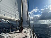
The sea voyage under sail is usually slow, an intimate affair, which leads to reading and reflection, with time expanding to take on increasingly blurred contours and regulated by more natural than constructed rhythms; the sun is the master of the day, the moon and the stars of the night, and then there are the wind and the sea that are not always watching, but dictate the rhythm. This crossing had them as conductors. This stretch of sea, no longer the Atlantic Ocean, but the Caribbean Sea, covers a distance of over 1000 miles from east to west and 500 to north; a particular ocean, which however has the geographical characteristics of a closed sea, framed as in a natural oval, with Cuba, Haiti to the north, the Caribbean barrier to the east, South America to the south and west, which contain the powerful energy that it struggles to express itself precisely because of the natural borders, therefore known for its rough waters, and its strong wind, never angry, but strong, so strong and constant, damn or fortunately constant. The wave motion, agitated by a lot of wind and the usual swell broken by distant reefs, however, is unable to vent the energy to the west, so the power of the sea bounces in depth and returns to shuffle everything, creating unexpected waves in strength and direction. So a violent and confused sea, with waves that easily reach 6 meters, but not always regular, as we would expect from an open ocean. A very demanding crossing, and very technical in the choice of the sail kit and the best weather route. What is a weather route? Today, computerized meteorological analysis systems can interface with our digital nautical charts, where we insert the starting and ending points, with the characteristics of the vehicle (we must enter the so-called polar, that is different numerical coordinates for each boat and which determine performance depending on wind conditions). The computer processes the data and gives us indications for the fastest route, which will never be a straight line from point A to point B, but will have shapes that derive from the meteorological variations of that route. However, a reliable meteorite does not exceed 3/4 days, just a little less than the time of this crossing.
The wind has never shown signs of tiredness or failure, it has always blown, not angry, but strong and decisive, never below 30 knots, with endless peaks at 37/38 up to 43 in gusts; more decisive in the northern part of the crossing, less violent further south. Obviously we chose the upper part, describing on the map a gentle parabola towards the north west, and then gradually descending towards the south west. Ariel has surpassed herself, in docility of maneuver, stability in sometimes violent conditions due to the irregularity of the waves that seem to come out of nowhere and suddenly rise and hit you; but she has always reacted like a real lady, so much so that she turned more into a solid ship than into a comfortable sailboat.
But the thing that surprised us the most is the speed we achieved. It is customary to record the miles traveled in the 24 hours in the logbook; normally they range from 150 (light winds) to 170 (fresh winds). On this route we recorded 196 miles on the first day, then 203 and 209, up to yesterday the maximum peak of 97 miles in 10 hours, or an average of 9.7 knots, (an absolute record for a 27-ton boat) and today that we are in the home straight, we will probably exceed 210 miles in 24 hours. Was it the analysis of the meteorite? The choice of timing for the jibe? Specially lengthened by about fifty miles to have an edge favorable to the use of Ariel’s trident? (The trident is my creation, that is, the unusual use of a tangled genoa at the bow, staysail on the opposite side, not left, but stretched just right, carried on the side of the mainsail, foiled and reduced by one hand). With an apparent wind at 150 degrees this configuration puts Ariel on a track, that is, it stabilizes the course and bow, we buy half a knot with 15 knots of wind, but 2 knots with 30 knots of wind, so yesterday we ran constantly above 10 knots of log . Or was it the current? always 1.5 knots in favor? Or the sails of the Olimpic Sail? It is always a sum of factors and above all the detail that makes an event special; in this case, at the analysis of the positions at 12 o’clock yesterday we were leading our group and absolute seconds. Wind, sea and current are the same for everyone, so in the last 24 hours we have taken care of every detail to keep the advantage. We will soon find out why there are 46 miles to go.
In the meantime we are going down towards the land and this large sea is partly held back by a giant promontory, like South America is a giant.
See you soon from the land of Simon Bolivar (who was then Venezuelan by birth, but Colombian at heart).
Paolo & Ariel